Let’s get this straight: most of New Orleans is technically a bowl. The city sits below sea level, nestled between the Mississippi River and Lake Pontchartrain, a geography that feels like a divine dare. “Go ahead, build a world-class city here… see what happens.” And we did.
The flood map, officially produced by FEMA, is the cheat sheet to this gamble. It divides the city into zones with thrillingly boring names like “Zone X” and “Zone AE,” each representing a different level of risk. Think of it as a Risk board game, but the dice are hurricanes and the penalty is you need a canoe to get to Café du Monde.
Fun fact: The map is constantly being updated. The last major overhaul in 2016 sent shockwaves through the real estate market, forcing thousands of homeowners into higher-cost flood insurance. Suddenly, knowing your Base Flood Elevation (BFE) became a dinner party topic.
Reading the Tea Leaves (and the Contour Lines)
So, you pull up the map. What are you looking for? First, find your address. See those squiggly lines that look like a topographical map of a washing machine? Those are elevation contours.
If you live in a dark blue or pink area on the map, congratulations! You are in a Special Flood Hazard Area (SFHA). You are basically living in a neighborhood with a swimming pool for a foundation. It means you have a 1% annual chance of flooding—the infamous “100-year flood.”
Here’s the kicker: that 1% chance is per year. Over a 30-year mortgage, that’s a 26% chance. Suddenly, that cute shotgun house with the wraparound porch feels a bit like a paper boat in a bathtub. The map doesn’t tell you if it will flood, but it tells you the odds.
 NOLA- New Orleans, LA | New orleans, Katrina, Flood map
Parades, Potholes, and Pumps
Living with the map means living with the pump system. New Orleans has one of the most powerful drainage systems in the world, a network of canals and giant pumps that are basically the city’s mechanical heart. When a storm hits, you don’t just watch the radar; you eavesdrop on the Sewerage & Water Board’s twitter feed.
Cultural reference: Ever notice how a second line parade will detour around a low spot? Locals have a sixth sense for where water pools. The map confirms what their feet already know. If a street is named “Bayou,” “Canal,” “Marais” (French for marsh), or “Swamp,” you can bet your bottom dollar it’s on the wrong side of the flood map.
Practical tip: Before you rent or buy, look at the Google Street View of your potential street during a heavy rain. You’ll see the evidence: cars parked on the neutral ground (that’s the median for you newcomers), sandbags stacked like art installations, and a general air of damp resignation.
Practical Tips for the Modern New Orleanian
First, get the Flood Factor app or use the FEMA Map Service Center. Check it obsessively before a big storm. It’s not being paranoid; it’s being prepared.
Second, elevate everything. Your washer, dryer, and that box of Mardi Gras beads you swear you’ll re-use? Give them a shelf. Even a few inches of water can ruin a month of your life. The French Quarter, famously built on higher ground near the river, can still get “flash flooding” from a standard thunderstorm.
Third, make friends with your neighbor. When the map becomes a reality, you want someone who owns a generator, a sump pump, and a cooler full of Abita. Community is the best flood insurance you can buy.
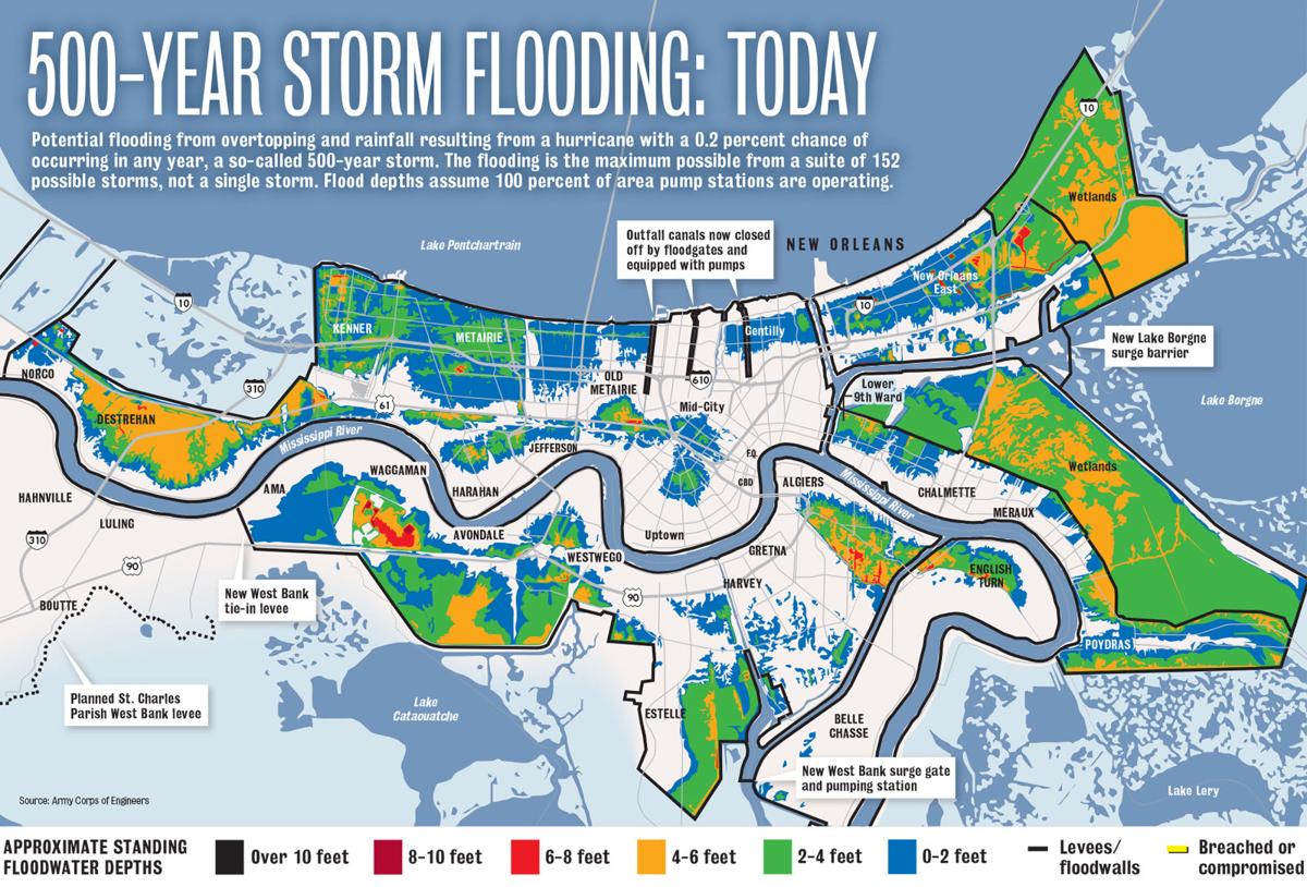 Hurricane Katrina flooding compared to a 500-year storm today: Graphic
Fun fact: The first flood map for New Orleans was created by the Army Corps of Engineers in the 1970s. Before that, people just… looked at where the water went. It was a much more honest, albeit terrifying, system.
The Beauty of the Low Ground
So why do we stay? Why does anyone live in a place that requires a government website to tell you how high your floor must be? Because the flood map is only half the story.
It doesn’t show the live oak trees dripping with Spanish moss, the taste of a po-boy on French bread, or the sound of a brass band echoing through the Quarter at twilight. It can’t measure the weight of history or the warmth of a city that has always danced on the edge of disaster. The map is about risk, but the culture is about resilience.
You learn to work with the water, not against it. You build houses on stilts. You move your car for a flash flood watch. You accept that a little water in the street is the price of a front-row seat to the most unique city in America.
A Reflection for Your Daily Life
In a way, we all have a personal flood map. The map of our own lives shows where the ground is soft, where the water might rise, where we need to build our walls a little higher. It’s the boundaries we don’t set, the stress we don’t manage, the commitments that drown us.
Just like in New Orleans, you can’t change the terrain. You can’t wish the river away. But you can elevate your priorities. You can check your emotional forecast. You can build a life that acknowledges the risk but refuses to be defined by it. So go ahead, buy the map. Then go dance in the rain. The water will come, but so will the parade.